Water Ways
Riparian Ecosystems

The area along a river’s edge is called a “riparian”. It’s home to many plants that use their roots to keep the dirt in place. The roots also filter out pollutants from the water flowing into the river. Other plants in the riparian area are used by birds to make nests.
In a semi-arid climate such as the South Okanagan, it is very important to protect these riparian areas to maintain plant and animal diversity for the whole region. Approximately 80% of the animals in the region are either directly dependent on riparian ecosystems or rely on them more frequently than other species and plants.
Water Underground

Groundwater is water found underground in the cracks and spaces in soil, sand, and rocks. It’s stored in and moves through geologic formations of soil, sand, and rocks called aquifers.
Aquifers are typically made up of gravel, sandstone, or fractured rock, like limestone. Water can move through these materials because they have large connected spaces that make them permeable. The speed at which groundwater flows depends on the size of the spaces in the soil or between the rocks and how well the spaces are connected.
Groundwater supplies are replenished, or recharged, by rain and snow melts that seeps down into the cracks and crevices beneath the land’s surface. In some areas of the world, people face serious water shortages because groundwater is used faster than it is naturally replenished. In other areas groundwater is polluted by human activities. Ground water can be polluted by landfills, septic tanks, leaky underground gas tanks, and from overuse of fertilizers and pesticides. If groundwater becomes polluted, it will no longer be safe to drink.
The South Okanagan receives approximately 30 cm of rain per year, making it very dry. There are lots of lakes and rivers in the North Okanagan, but in the south there are not as many. Since there isn’t a lot of surface water in this region area ground water is very important. A lot of our ground water comes from the snow melt in the spring from April-June, which runs into the Okanagan River and flows underground. In August, the river water evaporates and moves back up into the mountains as snow, ready to start the cycle all over again in the following year.
The Osoyoos Oxbows
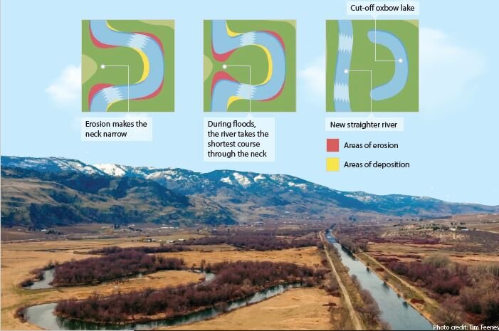
In 2017, the Nature Conservancy of Canada (NCC) announced the conservation of 36.4 hectares (90 acres) of wetlands in the South Okanagan. The Osoyoos oxbows, an area of wetlands located along the Okanagan River, have been added to a complex of conservation lands that run parallel to Highway 97 between Oliver and Osoyoos.
This area contains some of the last remaining marshes in an area that was once a significant chain of wetlands. The Osoyoos oxbows have been recognized for their bird diversity. The area is used for breeding, nesting, hunting, and is a critical migration stopover for many birds.
The Osoyoos oxbows are home to the only breeding population of bobolinks in the Okanagan Valley, as well as long-billed curlew and the yellow-breasted chat. All these species have been designated species at risk by the Committee on the Status of Endangered Wildlife in Canada (COSEWIC).
The Osoyoos oxbows conservation project returns some of the agricultural fields to a more natural state. Recreating the historic oxbows allows designated species at risk in the wetlands, such as the western painted turtle, Great Basin spadefoot toad, and blotched tiger salamander, to relocate from nearby areas and grow their diminishing habitat.