
ODHS archive image: 991.047.001
The ODHS offers in-person and self-guided versions of Heritage Walking Tours of Oliver
as part of our public education programming.
We are currently updating our Heritage Walking Tour. The in-person and self-guided versions will be available for the Summer of 2024. The website version (below) will be updated as well.
Stay tuned for more updates.

1. Railway Station (Station St.)
In order to facilitate the shipment of perishable fruit from the South Okanagan, a spur line of the Kettle Valley Railway was built in 1923, which the CPR leased beginning in 1931. This is a restored version of the building that originally sat further to the south on Station Street. The exterior is reminiscent of the CPR aesthetic and shows the fine lines of the Prairie school of architecture with its broad eaves, low roof line, and transom windows. With improvements to the road systems to Oliver, transport was increasingly shifted towards trucking. The last train went through Oliver in 1977. Today, the CPR station is home to the Oliver Visitor Center.
Go up Veterans Ave. to Main St.
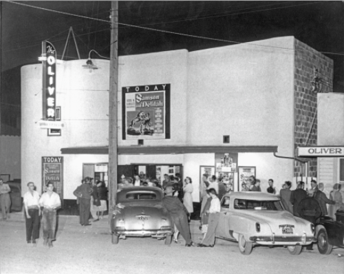
2. Oliver Movie Theatre (6367 Main St.)
This movie house was constructed in 1946 in the Streamline Moderne style during the ‘Golden Age’ of cinema. It was operated by Alex Gough who used his earnings from working at the Hedley Mine to build it. In 1964 it was sold to the Lesmeister family, who sold it to the current owners in 2018. Be sure to take in a show, enjoy real hot buttered popcorn and appreciate the family feel of the theatre.
Be sure to take in a show, enjoy real hot buttered popcorn and appreciate the family feel of the theatre.
Continue on Main St.

3. Downtown Oliver
The downtown core was developed between the 1920s and 1940s and reflects a variety of architectural styles that mesh together, creating a unique feel. The buildings have false facades associated with boomtown architecture of the Old West, with a twist. Although most boomtown buildings are constructed of wood, most in Oliver are done with cinder block construction. The building facades retain characteristics of Arts and Crafts, Plainsman and the Streamline Moderne movements. Onto these facades Industrial, Modernist, Post-Modernist and Mesa style accents were added, creating a visual feast.
Cross School Ave. and go right.

4. South Okanagan Lands Project Office (6150 Main St.)
Originally, this Edwardian Craftsman style building was the South Okanagan Lands Project (SOLP) office, and has always been recognized as the seat of authority for the community. The construction of this structure is interesting in that it is an ‘authority’ building that looks like a home. This is because, following WWI, symbols of government authority were shunned as part of the world-wide labour movement. Labour leaders held that government should be less prominent in people’s lives. When the SOLP project was complete and the Village Government took over, the building became the Oliver Town Hall.

5. John Oliver Commemorative Statue
This life-sized bronze statue of “Honest John” Oliver (1856 - 1927) by local artist Letta Shores was erected in April 2007. John Oliver was elected Premier of British Columbia in 1918 and was the driving force behind ‘The Ditch’ (see stop # 14). This statue was erected to serve as a reminder that this valley would not be the lush fruitful region it is today without the vision and determination of this amazing man.
At the light, turn right up Fairview Rd.

6. Oliver and District Archives
(430 Fairview Rd.)
The Oliver Archives, originally housed in the Oliver Museum, now resides in the former Ambulance Services building for the Town of Oliver. Opened in October 1997 the archives houses the documentary history of the area. Researchers and visitors can research the history of the area, past residents, the natural history of the region, and learn about the treasures being preserved here. Make note of the mural and Canada 150 mosaic on the front and side of the building. Can you identify the important parts of Oliver’s history?
Continue up Fairview Rd. to Kootenay Ave.

7. C.D. Collen House (6116 Kootenay St.)
This home, with its large turret, has been a local landmark since it was built in the 1920s. Constructed by Carl Daniel Collen, it is of the Italianate style, which was familiar to him in his formative years in Woodstock, Ontario. Most of the houses on this street reflect more of the vernacular style. Mr. Collen was a prominent businessman in Oliver for over 80 years and ran the Collen Department Store on Main Street which burned down in 1975.
Continue up Fairview Rd.

8. Christ the King Catholic Church
(522 Fairview Rd.)
This building was originally the Christ the King Catholic Church. Built in 1934, numerous additions were made over the years, including the current entrance in 1948. The battlements on each side of the front entrance, like the battlements on St. Edward’s Anglican Church and the Oliver United Church, represent the war-time history of Oliver and the special relationship it has with war veterans. The congregation moved to their current location on Spartan Street.
Continue up Fairview Rd. on Nicola St.

9. St. Edward’s the Confessor Anglican Church (5954 Nicola St.)
This building was constructed of pumice stone to emulate the construction of churches in Britain. Built in the 1950’s Norman style popular in the early 19th century in England, it looks very different from the old Secondary School that was located in the same spot as the current high school across the street. It is surprising to note then, that they were designed by the same architect! Note the castle battlements of the bell tower. This building was originally located across the street but was moved as it was in the flight path of the Airport.

10. Fairview Town Site
Should you choose to, take a drive up Fairview Road (4 km) and you will find the Fairview Town Site marked by an information kiosk. Settlement started here based on the prospect of gold in the 1890s but started to decline by 1910. At one time Fairview was considered the largest urban area in the Southern Okanagan! The site is now an ecological preserve overseen by the Oliver-Osoyoos branch of the Okanagan Historical Society. You will also find a walking trail along which you may see evidence of the former town. Enjoy your tour, but please do not go off the trails, dig on the site or remove any artifacts.
Go down Gala St. on your right .

11. South Okanagan Secondary School (SOSS)
The original South Okanagan Secondary School (SOSS) was built in 1948. It was often referred to as the “Taj Mahal” by locals. It suffered a tragic fire in 2011 and the current school was opened in 2013. The reconstructed school resembles the old design, following the Streamline Moderne style of WWII. It mixes modern geometric features with the bas relief disks on the auditorium. The new school is considered to be one of the most eco-friendly in BC.
When the original high school was built, there were emergency tunnels and an emergency shelter built underground in case of any wartime threats during WWII and the Cold War. These tunnels led to St. Martin’s Hospital across the street. However, the tunnels have since been removed.

12. St. Martin’s Hospital
St. Martin’s Hospital was constructed in 1942 and was run by the Roman Catholic Sister of St. Anne. St Martin’s treated many patients with T.B. and polio, which were major health issues in Oliver during the 1950s. It was closed in January 1973 and although the local community fought to try and save the hospital from demolition, it was torn down in 1981.
Continue down Gala St. At the corner of Gala and School Ave.

13. Oliver Elementary School (OES)
This name is misleading as it refers not to one building, but to 3 buildings over an 85 year period. The first was built in 1929, the second in 1941 and the third in 1964. The first was demolished in 1990 but the other two still stand as part of the current Oliver Elementary School complex.
Turn to the right and cross Gala St.

14. The Ditch
Gala Street represents the path of the West Lateral branch of the South Okanagan Lands Project, aka “The Ditch”.
“The Ditch” was an initiative created by Premier John Oliver to provide immediate and long-term economic opportunities for soldiers returning from WWI. The BC legislature paid $350,000 for 22,000 acres of land in the Okanagan region from McIntyre Bluff to the US border. Premier Oliver recognized the great agricultural potential in the region; but as the Okanagan is Canada’s only desert area, he needed to get water to the future farms and gardens. Thus began the South Okanagan Lands Project (SOLP).
The project consisted of a 25-mile long gravity-fed pipe and canal system constructed from cement, wooden siphons and flumes. Construction began in 1918 and ran until 1925. Many side industries including logging, sawmills, and engineering camps grew up to support the project. Oliver survives as a lasting monument to this immense undertaking.
The West Lateral branch (represented by Gala St.) carried water from the main pipe to the homes and orchards north of Oliver by following the side of the valley.
The modern pipes you are standing beside mark the western end of one of the SOLP projects greatest engineering marvels, a huge wooden siphon (photograph on the tour cover and below). The siphon ran up what is now School Avenue and without it, the West Lateral and the continuation of the Ditch would not have been possible. The water flowing along the pipe in this area moves uphill to this point, due in part to the laws of gravity!


Without the Ditch, Oliver’s landscape would look very different!
Go down School Avenue, back toward the Main Street. Stop at the corner of Kootenay St.

15. Dr. Ball’s Office
(475 School Ave.)
This building housed the office of Dr. Norbert Ball from 1933 – 1971. He also served during WWII on the front line in Europe. His service was so distinguished that he was offered the position of Chief Medical Officer for the Canadian Army, however, Dr. Ball declined the offer and returned here to develop health and wellness in Oliver, which included the construction of St. Martin’s Hospital. The apartments above the office were used by doctors working on-call at the hospital. Constructed in the Streamline Moderne style, the glass block, broad false pillars and mantle around the door are all typical of this form of architecture.
Cross the street and finish your tour with a visit to the Oliver Museum.

16. Oliver and District Museum
(474 School Ave.)
Originally built in 1924 as a combination home and detachment office for the British Columbia Provincial Police, (BCPP) this is the best preserved BCPP rural detachment office in the Province. It served as the home to the BCPP, RCMP and Circuit Court until 1966. Since 1980, this has been the home of the Museum. In 1981, the Fairview Jail, one of the few remaining buildings from the old Fairview town site, was relocated to the Museum property.
We hope you enjoyed your time learning about Oliver!
Please consider making a donation to support our educational programming
100% of all donated funds goes towards preserving and presenting Oliver’s history through artifact care, research, and programming. Thank you for helping us to preserve local history.